M3.0 - 40km SSE of Caliente, Nevada 2013-01-09 13:50:47 UTC
Welcome to the NSL !
A Research Division within the UNR College of Science....

|
Member Advanced National Seismic System | http://www.seismo.unr.edu/ |
Latest Event

Notable Earthquakes
 2011 Hawthorne Earthquake Sequence
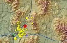 2008 Wells Mw 6.0 Earthquake
Announcements

 Google Earth KML
Summary
Location and Magnitude contributed by: Nevada Seismological Laboratory
General
50 km
50 mi
Powered by Leaflet
Nevada
37.273°N, 114.363°W
Depth: 5.8km (3.6mi)
37.273°N, 114.363°W
Depth: 5.8km (3.6mi)
Event Time
- 2013-01-09 13:50:47 UTC
- 2013-01-09 05:50:47 UTC-08:00 at epicenter
- 2013-01-09 07:50:47 UTC-06:00 system time
Location
37.273°N 114.363°W depth=5.8km (3.6mi)Nearby Cities
- 40km (25mi) SSE of Caliente, Nevada
- 57km (35mi) NNW of Mesquite, Nevada
- 71km (44mi) WNW of Saint George, Utah
- 77km (48mi) WNW of Washington, Utah
- 442km (275mi) SSW of Salt Lake City, Utah
http://earthquake.usgs.gov/earthquakes/eventpage/nn00399130#summary
Severe Weather Threat in Louisiana, Mississippi, Arkansas


News
Severe Weather Threat in Louisiana, Mississippi, Arkansas
Published: Jan 10, 2013, 5:39 AM EST
weather.com
Severe Threat
While heavy rainfall will be the primary threat, a few severe thunderstorms are possible Thursday in the Lower Mississippi Valley.
A brief damaging wind gust and, perhaps, a rain-wrapped tornado embedded in the line of thunderstorms is possible as it marches only slowly eastward.
(MORE: TOR:CON tornado risk forecasts)

Record Streak
It's been 199 straight days without a single U.S. tornado death, which beats the old record streak from 1986 and 1987.
This is despite a 61-mile long tornado with up to EF3 damage on Christmas Day in southern Mississippi, not to mention over two dozen other tornadoes that touched down during that outbreak.
(MORE: Christmas tornadoes)
We have all the maps you need to track severe weather below, including watches and warnings, and radar.
We also have links to see what your typical climatological tornado risk is, as well as links to our iWitness photo/video galleries and our Notify! severe alerts service.

Severe Alerts
Active Watches and Warnings
See the latest watches and warnings across the nation using our clickable severe weather alerts map.Regional alert zooms:
- Northeast | East Central | Southeast
- North Central | Central | South Central
- Northwest | West Central | Southwest

Current Radar
Track the Storms in Your Area
Track the severe thunderstorms using our interactive radar map.You can also see how much rain has fallen by clicking on the 24-hour rainfall interactive map.


Madtown Preppers Alerts are for informational use
only. These alerts purpose is to inform you of news events in order for
you to adjust your family preparedness programs. We believe that
knowledge is power and in order for you to make informed decisions, we
try and bring you verified information, not to increase fear but to
inform you. We do not endorse any of the sources we link to in any
article.
No comments:
Post a Comment