Sustainable Survival/Emergency Preparedness Information and Alerts
+SITUATIONAL PREPAREDNESS
"There's a difference between Knowing the Path, and Walking the Path." - morpheus ca. 2072
BUFFALO, NY – National Grid Corp. hopes to learn within a few days what sparked a fire involving some underground electrical cables, which resulted in an explosion that sent a manhole cover soaring several stories in the air in downtown Buffalo on Sunday. "They pulled all the bad cable out and it will be sent off to a lab for testing and examination," said National Grid Spokesperson Steve Brady."However, sometimes it is burned up so badly that they are not able to completely tell. But it's going to take at least a couple of days to determine before we have an answer." Common causes generally include aged cables, excessive salt and water from a harsh winter, which can get in and deteriorate them, or even rats chewing on them, according to National Grid. According to Brady, it is common for there to be a rapid buildup of heat and gas during a fire in an underground conduit, which is after all a confined space. On somewhat rare occasions, there can be an explosion with enough force to move a heavy manhole cover. Extremely rare, he says, is when a cover is sent rocketing into the air. ."In most cases what will happen when a cover comes off is it will essentially pop but maybe move a couple of inches or a couple of feet….the one we witnessed (Sunday) is, fortunately, exceedingly rare."
WGRZ - Channel 2, Buffalo Photojournalist Dave Harrington captured the loud explosion and rocketing manhole cover on video. Check out the Graphics displayed:"Under Control" - Right.#WGRZ
(Amazing Video via WGRZ) #ElectricalFire #Buffalo #ExplodingManhole
Forget about all the Bison, Gerbils, Squirrels and Hippies "Running for their Lives" from the Yellowstone "precursor" tremors. Most of that is hype or overplayed..
When the scientists are moving this fast, there might be more that is not being reported.
A wise man said: "If the Govt starts digging foxholes, you might want to grab a shovel."
Be Prepared for Earthquakes. Every Day. Create a Plan.
With Hundreds of earthquakes swarming central
Idaho since last month, Idaho's Mount Borah area near Challis has seen the worst of it.
So far..
The
recent earthquake swarm, beginning on March 24 and climaxed by a 4.9
magnitude tremor on Saturday, has produced no reports of injuries or
severe damage but has rattled nerves in a region where Idaho's most
powerful known quake, measured at M6.9, killed two children in 1983.
Saturday's earthquake was the strongest recorded in the state since 2005
and was followed on Monday by a M4.4 event that struck 10
miles north of the small ranching community of Challis, Idaho, according
to the U.S. Geological Survey. The Challis tremor knocked pictures and
animal mounts from walls, rattled dishes off tables and was felt by
residents in neighboring Montana more than 100 miles from the quake's
epicenter, officials said. The latest seismic surge, including 100 small
to moderate quakes on Monday alone, has galvanized government
scientists, who planned to install special seismometers in the area as
early as Tuesday to more closely track the activity.
"The likelihood of a severe earthquake coming on the heels of the recent
swarm is low, but much is perplexing about the series of tremors," said
Bill Phillips, a geologist with the Idaho Geological Survey at the
University of Idaho. "Such earthquake swarms typically are associated
with the movement of molten rock below ground, which geologists credited
for the recent quake cluster at Yellowstone National Park, or they are
linked to an active fault", he said on Tuesday. "What has many of us
scratching our heads is the present-day swarm doesn't appear to be on
the big, active fault in the area that ruptured in 1983 and caused the
largest earthquake in Idaho," Phillips said. He was referring to the
M6.9 that struck Mount Borah, Idaho's tallest peak,
killing two children in Challis and damaging hundreds of homes and
businesses. Idaho sits at the center of a seismic belt in the inter mountain West that runs from northwestern Montana to southern
Nevada and contains thousands of faults in the Earth's crust, said
Michael Stickney, director of earthquake studies at the Montana Bureau
of Mines and Geology. Carl Alexander, disaster coordinator in Challis,
said schools have stepped up earthquake drills, and he has requested
that emergency responders in Idaho and Utah be available if disaster
strikes. Alexander is advising local residents to keep bottled water and
canned goods on hand just in case "a big shaker" should strike.- RSOE/Reuters
The massive #sinkhole that opened up under a Kentucky museum Wednesday morning swallowed several vintage and rare Corvettes.
The #NationalCorvetteMuseum said the Bowling Green Fire Department
estimates the sinkhole to be around 25-30 feet deep and 40 feet wide.
"This is going to be an interesting situation," Museum Executive Director Wendell Strode told the Bowling Green Daily News, noting that a structural engineer is at the Bowling Green facility to evaluate the damage inside its Sky Dome section.
Six of the cars in the sinkhole are owned by the museum; two others are owned by General Motors.
The earth moved with enough force to create a small island visible off
the southern coast after the huge tremor, said Pakistani officials.
Pakistan quake kills more than 200 people; island appears
By CNN Staff
updated 2:40 AM EDT, Wed September 25, 2013
The head of the Geological Survey of Pakistan confirmed that the mass
was created by the quake and said scientists were trying to determine
how it happened. Zahid Rafi said such masses are sometimes created by
the movement of gases locked in the earth under the sea, pushing mud and
earth up to the surface in something akin to a mud volcano.
SkyTruth, July 24, 2013: We just saw this report filed (we assume) by Walter Oil and Gas with the Coast Guard’s National Response Center claiming that there is a crude oil spill associated with this incident, and estimating that the spill rate is 7 barrels (294 gallons) per hour.
Los Angeles Times, July 26, 2013: A slight sheen associated with spilled oil is still being detected on the water’s surface but is dissipating, according to a joint statement by the federal Bureau of Safety and Environmental Enforcement, the Coast Guard, and the company involved, Walter Oil & Gas Corp.
AP, July 26, 2013: A slight sheen was visible again but quickly dissipating Friday [...] Light sheens, quickly dissipating, have been reported each day since the blowout. In addition to government monitoring, scientists from a multi-institutional project called the Ecosystem Impacts of Oil and Gas Inputs to the Gulf Consortium plan a cruise Saturday to gather water samples.
The recent Gas Rig Explosion and fire on the Hercules 265 rig in the Gulf of Mexico has again raised concerns over the seismic stability in the region. As reported here earlier in the week, MP has also discovered new info regarding the #BayouCorne #Sinkhole dispelling Methane and #NatGas.
As we are not really in the "TinFoil Hat" business lately, these events and #Fracking quakes in the area are all separate anomalies AND distinct Precursors to an oncoming bigger event.
[The fire engulfed..] drilling rig off the Louisiana coast that was
surrounded by a “major cloud of gas” after it experienced a blowout,
officials said late Tuesday.
Stacey Plaisance, AP Reporter: [...] The gentle bubbles, actually natural gas spewing from a 22-acre sinkhole caused by a collapsed salt cavern.
John Boudreaux, Assumption Parish Office of Emergency Preparedness: There could be an explosion hazard and/or methane does displace oxygen, so by displacing oxygen then it becomes an asphyxiant.
WE will cover this event and Preparedness information on tonight's #SitPrep on USAEBN
Drilling rig on fire, begins to collapse; relief well to be drilled [...]
“Gulf of Mexico rig exploded Tuesday evening, causing drill floor and derrick to collapse” SOURCE: Times Picayune (Coast Guard photo)
Portions of the Hercules drilling rig that is on fire in the Gulf of Mexico started to collapse Wednesday.
The parts of the Hercules 265 rig that stick out over the Walter Oil
& Gas platform and wel lhead have been melting and falling, but the
integrity of the massive post-like legs and the permanent platform
itself appear to still be strong, Walter Oil & Gas spokesman Brian
Kennedy said. [...]
The federal offshore safety agency reported that beams supporting the
derrick and rig floor on the Hercules have folded and collapsed. [...]
Recent Activity in the Gulf of Mexico and #BayouCorne Sinkhole have raised our Alert Levels.
The above screen grab from Array Network Facility and updates the current #EQ in the US>> Note: the activity of the #NewMadrid Seismic Zone of recent days has many concerned. Note: As covered by RadChick on FB, the USGS has announced a Survey of the New Madrid Seismic Zone for magnetic field research.
Blaze erupts on Gulf of Mexico rig after natural gas blowout - NBC
A natural gas well off the Louisiana coast caught fire, hours after a blowout that prompted the evacuation of 44 workers. -NBC
By Christopher Nelson and Henry Austin, NBC News
A fire erupted on drilling rig off the Louisiana coast that was
surrounded by a “major cloud of gas” after it experienced a blowout,
officials said late Tuesday.
The blaze began about 10:50 p.m.
local time (11:50 p.m. ET) on the Hercules 265 natural gas platform,
which is located around 55 miles off the Louisiana coast in the Gulf of
Mexico.
Eileen Angelico, a spokeswoman for the Bureau of Safety
and Environmental Enforcement, said no one was on board when the fire
started. The cause of the blaze was unknown early Wednesday.
She
added that personnel from Wild Well Inc had been brought in to try and
get the well under control, but when they’d approached the blaze Tuesday
night they’d determined it was unsafe to get any closer when they were
200ft away from it.
The BSSE also said that a specialist boat, with both water and foam
firefighting abilities, had been dispatched to tackle the blaze.
Earlier on Tuesday, 44 workers were evacuated on two lifeboats after the gas began spewing to the surface. None of them were injured, NBC station WDSU reported.
A
Coast Guard cutter and two aircraft were sent to assess the situation
and BSEE inspectors reported that a cloud of natural gas had formed over
the well.
“A light sheen could be seen on the water one-half mile by 50 feet,” the BSEE said in a statement on Tuesday, adding that the sheen appeared to be quickly dissipating.
The
portable drilling rig known as a jackup rig, was operated by Hercules
Offshore. In a news release, Hercules Offshore said that they were
working for Houston-based Walter Oil & Gas Corp.
Walter Oil
& Gas reported to the BSEE that the rig was completing a "sidetrack
well" — a means of re-entering the original well bore, Angelico said.
Sidetrack wells are sometimes drilled to remedy a problem with the existing well bore.
"It's
a way to overcome an engineering problem with the original well," Ken
Medlock, an energy expert at Rice University's Baker Institute told the
Associated Press. "They're not drilled all the time, but it's not new."
In
2010, the Deepwater Horizon oil rig exploded off the Louisiana coast,
killing 11 workers and eventually spewing millions of gallons of oil
into the Gulf of Mexico.
Almost a year after a salt cavern collapsed near a scenic south
Louisiana bayou, the sinkhole has grown to 22- acres and is still
releasing oil and natural gas. Hundreds of residents have evacuated but a
few stayed behind despite the danger... - KIRO-7
Stacey Plaisance, AP Reporter: [...] The gentle bubbles, actually natural gas spewing from a 22-acre sinkhole caused by a collapsed salt cavern. John Boudreaux, Assumption Parish Office of Emergency Preparedness: There could be an explosion hazard and/or methane does displace oxygen, so by displacing oxygen then it becomes an asphyxiant. Carla Alleman, former Bayou Corne resident: We’re never going back [...] We’ll never feel safe there again. They can never say that it will be safe there again. [...]
Published: July 21st, 2013 at 3:13 pm ET
By ENENews
WWL – AM870,
July 21, 2013: Parish workers discovered water and debris moving inside
the containment berm area early Friday. Bubbles on the water’s surface
indicated a gas release, and there were tremors felt in the area. [...]
The periodic ‘burp’ was the second in two days and the fourth in the
past two-and-a-half weeks, according to parish officials. [...] The
[blue ribbon] commission, thus far, has not been able to come up with a
reasonable prediction of what the future holds for the area.
The Advocate,
July 20, 2013: The 24-acre Assumption Parish sinkhole underwent a
periodic burp early Friday [...] on Friday, Conservation Commissioner
James Welsh ordered Texas Brine Co. to cease a type of earth-probing
test aimed at seeing where gas is in the shallow rock under Bayou Corne.
[...] In addition to the sinkhole, gas is being released from bubbling
sites in area bayous and is thought to be gathered in an aquifer and
even in shallower rock under the communities. Welsh’s order follows
Boudreaux’s cease and desist order to Texas Brine earlier this week
after residents complained about a plugged probe site leaking gas in
front of homes [...] he tested the hole and found leaking gas at a
concentration that was approaching an explosive level. See also: Video: Official unable to find bottom of giant Louisiana sinkhole during depth survey -- All of 750 foot measuring cord used
This is the 2nd major blowout in the
gulf in two weeks , with very little main stream coverage . The
Louisiana sinkhole is deeper than 750ft and could be letting off
explosive Gases.
New
Madrid Fault Zone Alert - Information Only 19.12.2012 - Update. A
couple of things happen when you watch for Signs. A lot of Strange
Seismic Events sometimes (most) are Pre-Cursors to Larger Events. This
ALERT is for ...
Here
and there earthquakes are more numerous, for example in the New Madrid
seismic zone centered on southeastern Missouri, in the
Charlevoix-Kamouraska seismic zone of eastern Quebec, in New England, in
the New ...
Seismic
Alert: New Madrid Earthquake Swarm - LA Sinkhole - Large area of Gas
Bubbling - Information Only - 26.12.2012.
madtownpreppers.blogspot.com/2012/11/new-madrid-fault-zone-alert-information.html.
Watching ...
Illinois
Basin - Oazark Dome Region This large region borders the much more
seismically active New Madrid seismic zone on the seismic zone's north
and west. The Illinois basin - Ozark dome region covers parts of
Indiana, ...
Madtown Preppers Alerts are for informational use only. These
alerts purpose is to inform you of news events in order for you to
adjust your family preparedness programs. We believe that
knowledge is power and in order for you to make informed
decisions, we try and bring you verified information, not to
increase fear but to inform you. We do not endorse any of the
sources we link to in any article.
Browse through our store and shop with confidence.
We invite you to create an account with us if you like, or shop as
a guest. Either way, your shopping cart will be active until you
leave the store. We Ship Immediately. 100% Guarantee. Thank you for visiting. @NebudchenezzarS
Recent Activity in the Gulf of Mexico and #BayouCorne Sinkhole have raised our Alert Levels.
The above screen grab from Array Network Facility and updates the current #EQ in the US>> Note: the activity of the #NewMadrid Seismic Zone of recent days has many concerned. Note: As covered by RadChick on FB, the USGS has announced a Survey of the New Madrid Seismic Zone for magnetic field research.
Starting around July 10, 2013, an airplane operating under contract to the USGS will be making low-level flights over a 1400-square-mile area in the New Madrid Seismic Zone.
[...] as our video and photos from today attest, whatever false sense of security that berm provided is now gone forever. And with it, the residents’ last remaining hope that the sinkhole could be contained and they might be able to move back into their homes and their lovely way of life. [...]
Let’s preface this with a sobering comparison of a few photos taken today with some we took last August [...]


 , noting that a structural engineer is at the Bowling Green facility to evaluate the damage inside its Sky Dome section.
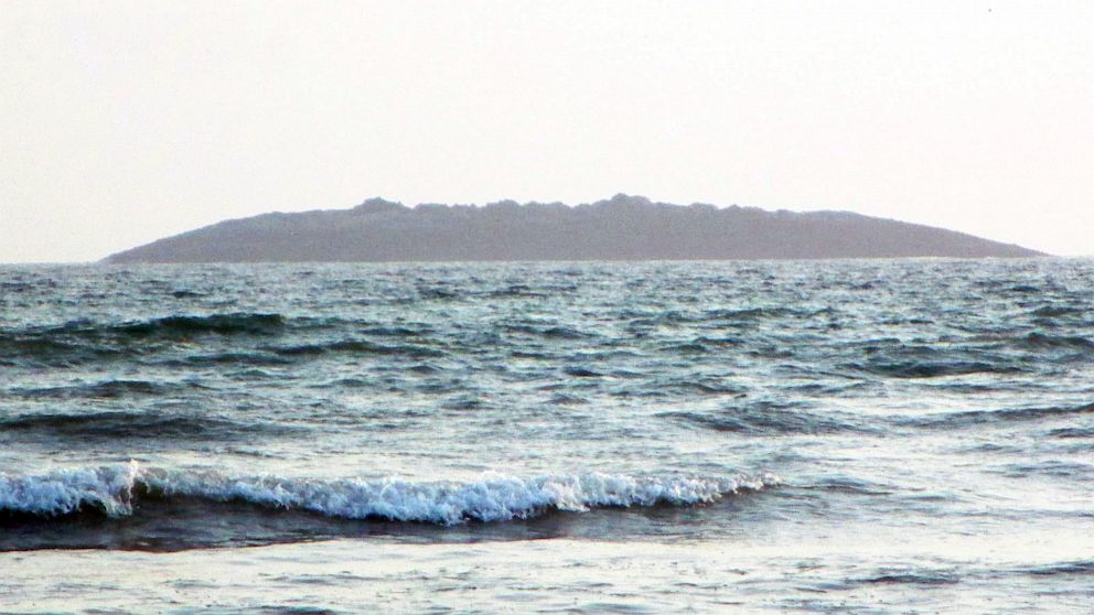


